|
|
The Rescue Project | ||
| Main | Project Members | Robots | Research | Publications | Status | Pics and Movies | Press | Links | Contact | |||
This project carried out at the Institute for Systems and Robotics will endow a team of outdoors robots with cooperative navigation capabilities, so as to demonstrate the ability of the robots to act individually and cooperatively in search and rescue-like operation scenarios. Search and Rescue (SAR) operations are a challenging application for Robotics since, due to their nature, they naturally foster advances in Artificial Vision, Navigation in outdoors unstructured environments, Distributed Artificial Intelligence and Intelligent Control.
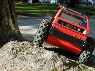
The long-term objectives of the project consist of applications to SAR under large-scale catastrophe scenarios, namely after an earthquake. However, the current proposal is focused on the first steps towards the long-term goal and, as such, it refers to simpler scenarios and is based on some simplifying hypotheses, such as daylight operation and pre-planned robotic tasks. Also, the robotic team will include only 2 robots, purposively made heterogeneous, both regarding the functional, hardware and software architectures: one wheeled and one aerial robot. Therefore, each type of robot can be assigned tasks with different requirements under SAR operations.
The following is a list of problems that will be addressed and, at least partially, solved during the current project:
The project work plan is divided in 5 tasks. During Task 1, the functional architecture and its relationship with the software and hardware architectures will be specified. After this step, more detailed design requirements will be established, with special emphasis on navigation. Task 2 will consist of specifying, integrating and assessing the hardware and software to be used to demonstrate the project results, mainly the 2 robots, their sensors and actuators. This will have an impact on Task 1 definition of design requirements, as those are constrained by the equipment technical specifications. Therefore, the 2 tasks run in parallel. Tasks 3 and 4 cover the most relevant short-term project objectives, since they will handle individual and team navigation. Different approaches to navigation will be compared, such as world-based, sensor-based and topological navigation. GPS, gyroscopes, accelerometers, vision and laser-based sensors will be used for this purpose. Cooperative navigation will be modeled as a hybrid system. Project results will be demonstrated and assessed during Task 5, at the end of the work plan, through an application to a simplified SAR-like outdoors scenario. Special attention will be taken to the sub-systems integration under this task.
Surf this web-site using the navigation bar above - it will be present in each and every page for ease of use.